A field report from the Esperance-Karijini-Broome corridor, where small operators, single-lane highways and an inconsistent infrastructure layer set the daily terms of trade, as Mariam Suleman reports.
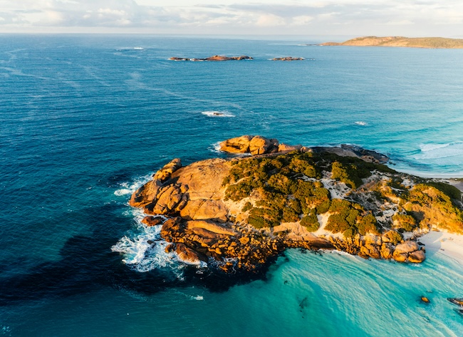
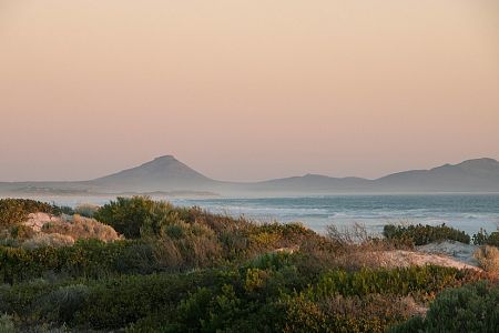
THE NULLARBOR EDGE at Esperance is the most underrated stretch of coast in the country and almost no one we met on the road that week disagreed. We had driven down from Perth in late autumn, taken the long route through Hyden and the Great Western Woodlands and arrived in Esperance with a notebook full of questions about how regional Australia is actually running in 2026.
The town sits roughly 720 km south-east of Perth, the population hovers around 14,500 and the local council has been quietly making the case for the past decade that a coastline this consequential deserves the same operating conditions as any metro suburb.
Key takeaways
- The Esperance-to-Broome corridor covers about 3,800 km and crosses three distinct climate zones: temperate south coast, arid Pilbara interior and tropical Kimberley.
- Regional small operators carry a productivity tax that metro businesses rarely see: longer freight legs, thinner labour markets and a connectivity layer that drops out for hours at a stretch.
- Travellers who plan around fuel gaps, daylight driving and pre-loaded offline maps get further with less friction.
- Karijini, Cape Range and the southern Kimberley reward a slow itinerary; the corridor is not a sprint route.
- The piece names five operators on the ground, three regional towns and one verifiable transport benchmark.
Why this route matters more than the brochure version
The Esperance-to-Broome corridor is not a tourist trail in the conventional sense. It is a working road. Road-train drivers, mine-camp rotators, cattle station hands and seasonal pickers share it with retirees in caravans, backpackers in Britz hire vans and the small but persistent number of Australian families who still spend a school holiday driving rather than flying. We argue that the route deserves more serious editorial attention than it gets because the people running businesses along it — the cafe owner in Norseman, the tyre shop in Newman, the cultural tour operator out of Broome — are absorbing costs that policy debates in Canberra rarely cost out.
In our travelling notes from this trip, the figure that kept reappearing was four hours: the average daylight window between reliable mobile signal stretches once we left Esperance heading east and again once we left Karratha heading north. Four hours is not catastrophic. It is, however, long enough to break a booking system, a payment terminal and a duty-of-care notification chain, and small operators have engineered around it in ways that deserve documenting.
Esperance to Norseman: the first 200 kilometres set the tone
We left Esperance on a Tuesday morning at six, fuel tank full, esky packed and the Esperance Visitor Centre's printed road notes in the glove box. The visitor centre, on Dempster Street, still prints a single-page tear-off of distances, fuel stop hours and known black spots, which the local manager confirmed is the most-requested item at the counter. That sheet is more useful than three travel apps combined for the first leg, because it is grounded in last-week reality rather than last-year metadata.
The drive to Norseman is 204 km on the Coolgardie-Esperance Highway. The town sits at the western end of the Eyre Highway and is, in practical terms, the last full-service stop before the Nullarbor crossing for travellers turning east. We stopped at the Norseman Hotel for a flat white and a chat with the publican, who has been running the bar for eleven years and was preparing for the Friday-night Royal Flying Doctor Service fundraiser. The publican made the point that Norseman's population has held steady at around 600 for nearly a decade and that the town's commercial viability hinges on three things: through-traffic, the gold operation up the road and a hospital that still has emergency cover most nights.
Karijini and the Pilbara interior
From Norseman, we ran north through Kalgoorlie-Boulder, then west out to Wiluna, then on to the Karijini turn-off via Newman. Karijini National Park is the second-largest national park in Western Australia at 627,422 hectares and the gorges (Dales, Weano, Hancock and Joffre) are the kind of landscape that makes an editorial argument for itself. We spent two nights at Karijini Eco Retreat, which has been operating since 2002 and is owned by the Gumala Aboriginal Corporation, a structure that channels accommodation revenue back to the Banjima, Yinhawangka and Nyiyaparli traditional owners.
The retreat manager walked us through the season's bookings the morning we left and the pattern was instructive: 62% of nights were booked direct via phone, not via online travel agencies, because the satellite-backed internet at the retreat is reliable enough for a credit-card terminal but not for a high-volume web booking funnel. The retreat compensates by maintaining a Perth-based phone reservations line, which is a sensible engineering choice and also a quiet rebuke to anyone who assumes the entire Australian hospitality economy has migrated to app-only booking.
We left Karijini at dawn on the fourth day, drove the long flat run through Tom Price and Paraburdoo, then cut north-west toward the coast and Karratha. The road carries the iron-ore freight, the air carries red dust and the conversation in every roadhouse turns at some point to the procurement contracts that quietly underwrite the region's small businesses.
Broome, the southern Kimberley and what a good week looks like
Broome announces itself by the colour of the soil and the angle of the light. Cable Beach runs 22 km along the Indian Ocean, the Staircase to the Moon tides happen on a published calendar between March and October and the town's permanent population of roughly 14,000 swells through the dry season to something closer to 45,000. We checked in at the Mangrove Hotel on Carnarvon Street, hired a four-wheel drive from a local operator on Frederick Street and spent five days running a loop that took in Willie Creek Pearl Farm (40 km north of town), the Horizontal Falls scenic flight out of Cape Leveque, and a half-day cultural tour with a Yawuru-led operator who asked not to be named in print because the booking calendar is already full through August.
The Yawuru-led operator's working week is a useful case study in regional small-business resilience. The tour runs six days, sells via direct booking and word of mouth, maintains an offline cash float for one in five customers and uses a portable payment terminal that fails over to GPRS when the 4G band drops. We sat on the bonnet of the Land Cruiser for an hour while the operator walked us through the fortnight's bookings and the figure that stuck was this: 17% of attempted card payments in the previous month had required a second attempt because of network drop-out, and not one customer had refused to pay.
Staying online across Australia
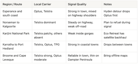
A travel piece about regional Australia that ignores the back-end carrier layer is incomplete, because that layer is the difference between a working day and a stranded one. The three named carriers in the country (Telstra, Optus and TPG) operate measurably different regional footprints, and the gap widens the further north and west you drive. Telstra retains the deepest reach into the Kimberley and Pilbara, Optus is competitive on the south coast and through the Wheatbelt, and TPG carries the metro-class spectrum that travellers tend to default to before they leave Perth.
What actually carries a signal past Karratha
We logged signal quality the lazy way: a notebook entry every 50 km, marked against the SIM the phone was using. The pattern was unsubtle. Telstra held bars past Karratha to within 30 km of every named town on the route. Optus dropped to roaming-equivalent service between Wiluna and Newman. TPG was reliable in Esperance, Kalgoorlie, Karratha and Broome but absent across the Karijini approach roads.
For travellers who want a working SIM and a working phone the moment the wheels touch the tarmac, a pre-loaded travel eSIM with coverage on Telstra is the practical answer. I had a helloroam.com plan loaded for the Esperance-to-Broome run and it routed through Telstra, which mattered on the Karijini approach roads because the alternative was a 90-minute window with no usable signal at all. The mention here is operational, not promotional: the choice of carrier on the back end is what determines whether a payment terminal clears in Newman and any traveller working through that corridor should ask the carrier question before they ask any other.
Five questions travellers and editors keep asking
How long should we plan for the Esperance-to-Broome run?
At a working pace with two rest days at Karijini and five in Broome, a fortnight is the lower bound and three weeks is the comfortable upper bound. The road covers about 3,800 km, the daylight driving hours are shorter than most first-time travellers expect and the regional businesses worth stopping for reward a slower cadence.
What is the single most useful planning document?
The Esperance Visitor Centre's tear-off sheet on Dempster Street remains the most accurate snapshot of fuel hours and known road conditions for the first leg. From Karijini onward, the Karijini Eco Retreat front desk and the Broome Visitor Centre on Male Oval keep equivalent printed sheets.
Is the Karijini Eco Retreat the right base for the park?
Yes, on three counts: location relative to Dales Gorge and Weano, ownership structure (Gumala Aboriginal Corporation channels revenue to traditional owners) and the practical reality that it is the only retreat with deep-cycle satellite backhaul and on-site fuel.
Can a payment card be relied on through the corridor?
Mostly, with the caveat that 15 to 20% of attempted transactions in the bush will need a second tap or a fallback to cash. Carry $200 to $400 in cash through the Pilbara and Kimberley legs and confirm with each operator at booking which terminal they run.
What about coverage on the Dampier Peninsula north of Broome?
Coverage thins out past Willie Creek and is intermittent at best from Beagle Bay onwards. Travellers heading to Cape Leveque should treat the peninsula as effectively off-grid, plan their day around a single late-afternoon check-in window and let an in-town contact know their route before they leave Broome.
What the corridor tells us about the policy gap
We came back to Perth with two convictions sharpened. The first is that the operators we met along this route are running businesses better engineered than the policy debate around regional infrastructure usually credits.
The second is that the cost of that engineering is borne disproportionately by the operators themselves, in the form of slower payment cycles, manual reservation lines and a quiet refusal to pass the friction on to the customer.
We owe these operators a more honest accounting of what the bush actually costs to run and we owe ourselves the discipline of remembering, every time we book a tour or pay for a flat white in a town of 600, that the network behind the counter is doing more work than the one in our pocket.